Imagining a Future Bangladesh
By Kazi Khaleed Ashraf and Saif Ul Haque
As economic and social transformations are ultimately related to realisations on the ground, on impacts to the physical and infrastructural landscape, a robust and integrated planning is required to deal with changes.
PricewaterhouseCoopers, in its global economic projection for 2050, estimates that Bangladesh can potentially become the world's 28th largest economy by 2030, surpassing countries like Australia, Spain, South Africa, and Malaysia in economic growth.
But there are also challenges when things move rapidly. As economic and social transformations are ultimately related to realisations on the ground, on impacts to the physical and infrastructural landscape, a robust and integrated planning is required to deal with changes. We are reminded of Bangabandhu Sheikh Mujibur Rahman's call for a “comprehensive planning… rather than doing something today, something else tomorrow, and something else day after… which will not solve problems” (1972). Planning at such a scale requires embracing a new imagination as conventional ones are not enough to deal with the enormity of changes.
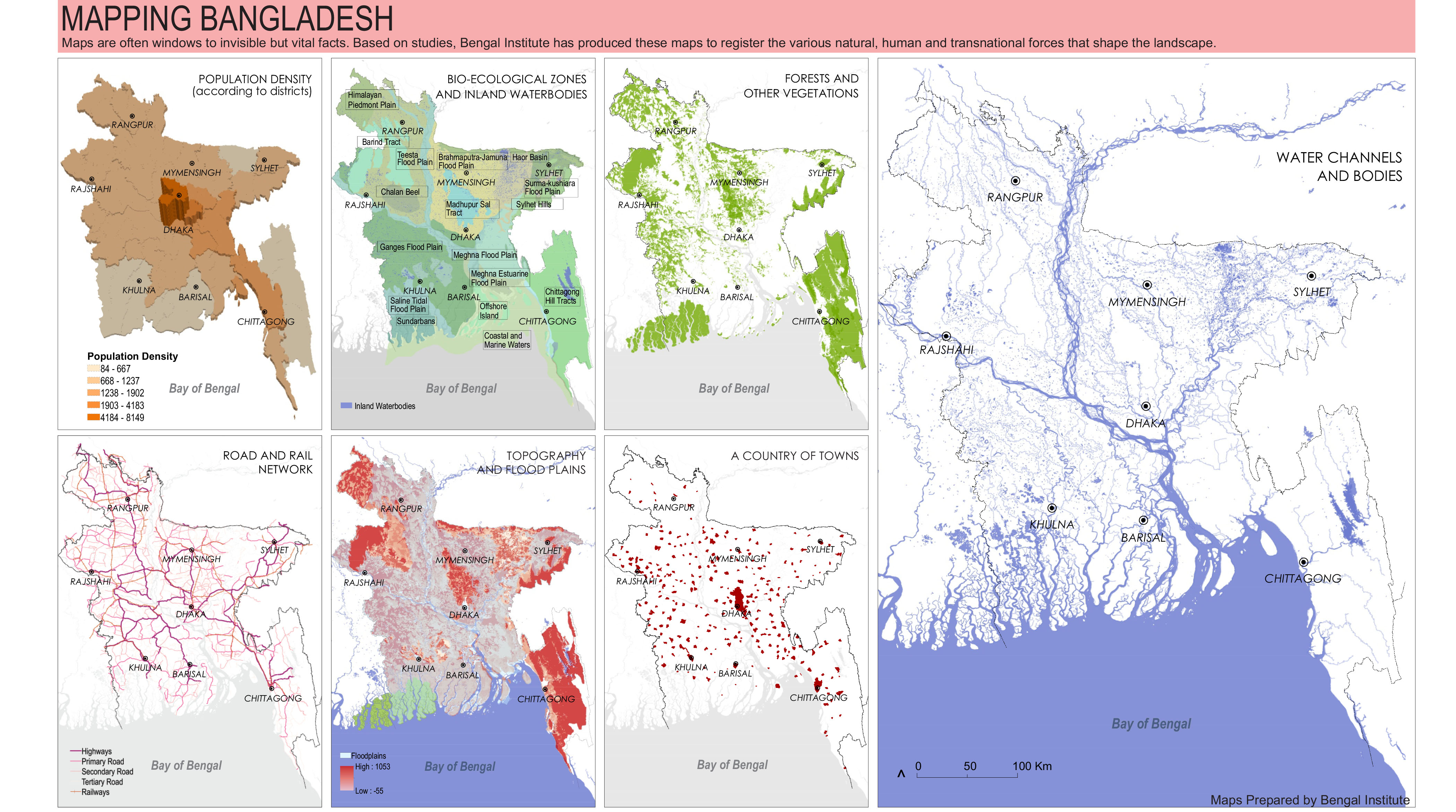
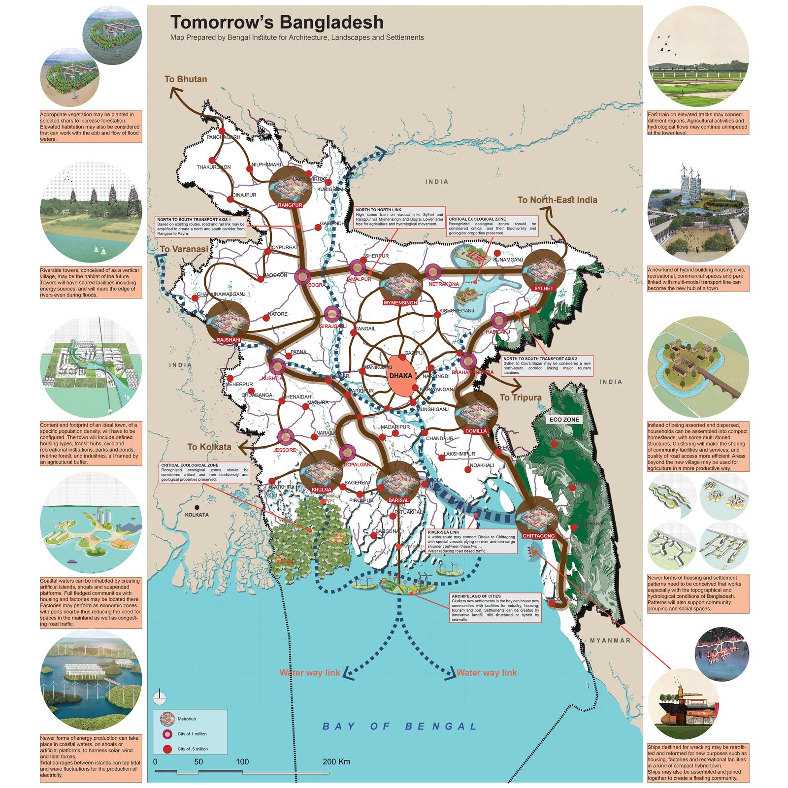
In visualising the future, we need an adjustment of the mental map of Bangladesh. A nation is not only narrated and officiated but also visualised; visualisation provides powerful perspectives for re-viewing the nation. The research and design team at Bengal Institute presents here a possible outline of that new map. Our future map adopts some of those ideas, includes additional ones, and presents them as an integrated image so that its starts to circulate in the national imaginary.
Water will remain the raison d'etre of Bangladesh. A hydrological thinking should be the foremost basis for a new imaginary, and consequently any planning action for the country. Bangladesh is a unique chemistry of land and water, it is not only deltaic, it is also estuarine. We have only imagined the country to be riverine however, Bangladesh can also be re-visioned as an oceanic one.
A hydrological consciousness will provide a wider understanding of the dynamics of water—its flows and counterflows, and its deep implications in the economic, ecological and life-world of the people. Issues of climate change are intimately connected to the realm of water. If sustainable development is to be treated seriously, in Bangladesh it ought to begin and end with water. As Prime Minister Sheikh Hasina has clearly directed: water needs to flow, silt managed with new initiatives, and riverbanks planned with new ideas.
While the economy has become the most powerful parameter of national development, economic drivers must align with ecological imperatives and life-world conditions. Land strapped, on the one hand, and demographically challenged, on the other hand, Bangladesh requires the planning and management of every square inch of its territory. A new physical planning is needed that redefines the territory of the nation, and frames new regional formations advancing the potential of each region.
What is needed, next in scale to the region, is a re-visioning of settlement and landscape patterns, and preparing a national agenda for an urban future. We have to admit that while Bangladesh maintains a rural ethos, it also has become a ‘country of towns’. New visions for cities and towns require standpoints on where cities should be, the footprint of each city, its civic constituents, the population and how it should relate to agriculture and flood-plains, and how each one can be consolidated with its own potentials, growth spurs and connectivity to neighbours. Similar questions should be asked for settlements at any scale, from the very rural to the semi-urban.
Development of a country cannot be based only on five or ten-year plans. “To envision the future,a hundred-year plan is needed” as Abul Khair, chairman of the executive board of Bengal Institute insists. Pointing out Professor Abdur Razzaq's truism that a developmental imaginary for Bangladesh will have to consider three resources—land, people and rivers—Abul Khair adds culture and tradition to it.
With maps and diagrams, we offer summary points for the imagined future.
Reterritorialising Bangladesh
Rearrangement of Bangladesh's international waters unleashes new possibilities, and encourages us to revise the understanding of the map that has so far prioritised land territory. With the opening up of an oceanic territory into the Bay of Bengal, new settlement, economic and transport opportunities are possible with a marine vision. We strongly support the 7th Five Year Plan (2016) that presented the value of a “blue economy” based on an oceanic scenario. While a prospect of that magnitude requires a huge infrastructural and planning investment, there is no reason to hesitate in slowly going into the seas.
Bangladesh is a terrain of water. From ancient to contemporary times, the presence of water in the form of rivers, canals and various water bodies has been inscribed in the imagination and practices of the people. The terrain should now be expanded. Riverine Bangladesh should flow into the imagination of an Oceanic Bangladesh. The Bay of Bengal can be the new frontier of Bangladesh offering a new and vast terrain of inhabitation, productivity and opportunity.
Settlements Should Be Reimagined
Utilising sedimentation in the Bay (700 million tons deposited annually at the mouth of Meghna estuary), we can imagine a new coastal landscape for Bangladesh that expands its territorial dimensions. We imagine an “archipelago of sea-towns” on artificial shoals and islands, and other constructed platforms, connected by causeways. While this will require massive infrastructural and investment input, and consideration of marine ecology and complex oceanic dynamic, this may be conceived through a careful combination of landfill, and offshore, floating, hybrid, and submerged structures. Construction of sea barrier walls can work as buffer against tidal surges and tsunamis.
An archipelago of sea-towns will be a uniquely constructed landscape hosting major industries and economic zones, with proper housing and urban amenities, as well as facilities for marine fishing and processing. Major port facilities may be installed there, perhaps with Payra as a hub of this projected development. It will be possible to install energy production hubs there utilising the environmental conditions of the sea. As part of the national initiative to face climate change, the constructed islands can be adaptive mechanism to face sea level change. In a landfill process, waste from the mainland can be collected and placed on artificial islets after proper processing (similar to Singapore's offshore landfill Semakau).
There are many examples of sea-based developments. Seasteading Institute has been advocating a sea-faring society, Singapore has landfill projects in the sea, Florida has numerous sea-links through its marine islands, the Dutch are building a seawall with new town development in the seas off Jakarta, and of course, half of Netherlands is built on the sea.
Rivers Can Generate New Possibilities
Bangladesh is dominated by the dynamics of riverine ecosystems made of rapidly moving and slow-moving waters, and areas of inundation. While the flow is generally towards the Bay, other complex forms of flows and overflows determine more localised conditions, and together create the character of the extensive delta system. Resilience and sustainability of the country undoubtedly depends on an intelligent but delicate management of the riverine ecosystem.
Silt—a production of river flows—is liquid land. Silt management rather than river management, should be a non-stop process with modernised, mechanised methods. Bringing more depth to rivers and canals by dredging, new riverbanks may be created by silt deposits.
Rivers as natural infrastructure remains as major lines of communication but can become more active and effective with better river management, shoreline planning, and modern water vehicles. If most cargo movement happens on rivers, roads may become freed from trucks and other vehicles. With modernised river dredging and planned silt depositing, shorelines can be planned for new habitation and architectural typologies, riverside forestation, and commercial setups. As the prime minister presciently noted in a recent meeting, this opens up new land opportunities that do not exist now.
Energy Innovation Is a Necessity
Energy will continue to be a critical factor in elevating Bangladesh towards a new economy, and maintaining that position. While conventional energy sources will remain, it is also the time to consider newer sources, most desirably renewable ones. Energy from solar, wind, and other methods need exploration at a large scale. Again, a coastal/oceanic territory offers opportunities in harnessing newer forms of energy. With the oceanic landscape as the site, battery of energy producing hubs or farms may be constructed harnessing solar and wind conditions, and tidal wave movement or sea current.
Based on a study of working examples elsewhere, we calculate that one acre of solar farm may yield 145 megawatt-hour of electrical energy. Similarly, an acre of wind farm but based on a larger setup may yield 139 megawatt-hour, while a tidal barrage with an enclosed reservoir of 5000 acres may produce about 90 megawatt-hour per acre.
Distributed Urbanism
In a country where land is scarce, we have to be inventive in creating spaces of habitation. A consolidated national plan is required to tame and manage the wild urbanisation that defines the current process. It is an absolute necessity to decide on and configure the settlement patterns as they impact the footprint of development, and form a disruptive relationship with agricultural land (affecting food security), wetlands and floodplains (impacting ecological and bio-diverse conditions). While we give more attention to metropolitan centres in our urban discourse, a similar attention is needed for smaller towns and other aggregations.
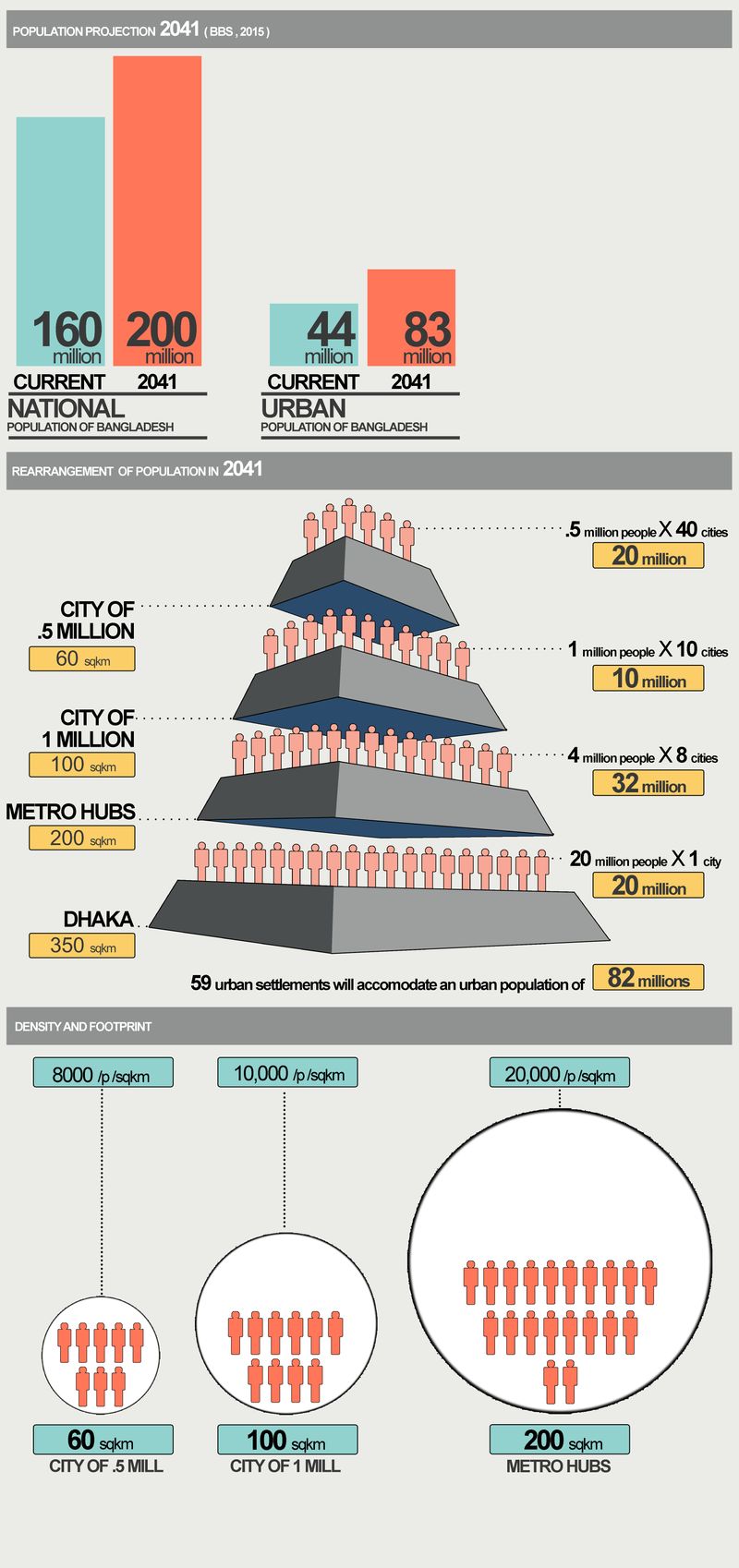
A key challenge in tomorrow's Bangladesh will be the state of urbanisation and housing the extra population expected by 2040. Planned agglomeration and distribution of future population will be critical for a sustainable economic and social development. Population projection puts the urban population at 83 million in 2041 (BBS), almost double of the current 44 million (BBS). At present, Dhaka city alone hosts 16 million people, with a density of 50 thousand per square kilometre. If the current trends of Dhaka-centric development continue in 2040, the city will have to accommodate another 30–35 million people. Chittagong, the next big city after Dhaka, has a population of 2.5 million with a density of 16000 per square kilometre. No other divisional headquarters has a population over 0.6 million (except Khulna).
For a balanced development, Bangladesh will need to have ‘metro cities’ beyond Dhaka which can absorb the extra population. By 2041, we can plan for 7–8 metro-hubs with 5 million each, 10 medium cities with 1 million plus each, and 40 smaller towns with 0.5 million each. Each of the metro cities, including Dhaka, can have a networked region composed of small and medium cities and villages in-between.
Being a country with a huge population in a small geographic boundary, Bangladesh needs to have cities with high density. Density, often cited as the culprit for urban ills, is not a factor in creating such liveable, walkable places such as Mong Kok in Hong Kong with a density of 130,000 people per square kilometre.
Population and density are associated with the footprint of settlements. For future redistribution of population, the metro cities can have a density of 20,000 per square kilometre that will require a footprint 250 square kilometre (for a total population of 5 million). The medium and small cities can have density of 10,000 and 8,000 with areas of 100 square kilometres and 60 square kilometres respectively.
Ecology Can Be Part of a Development Strategy
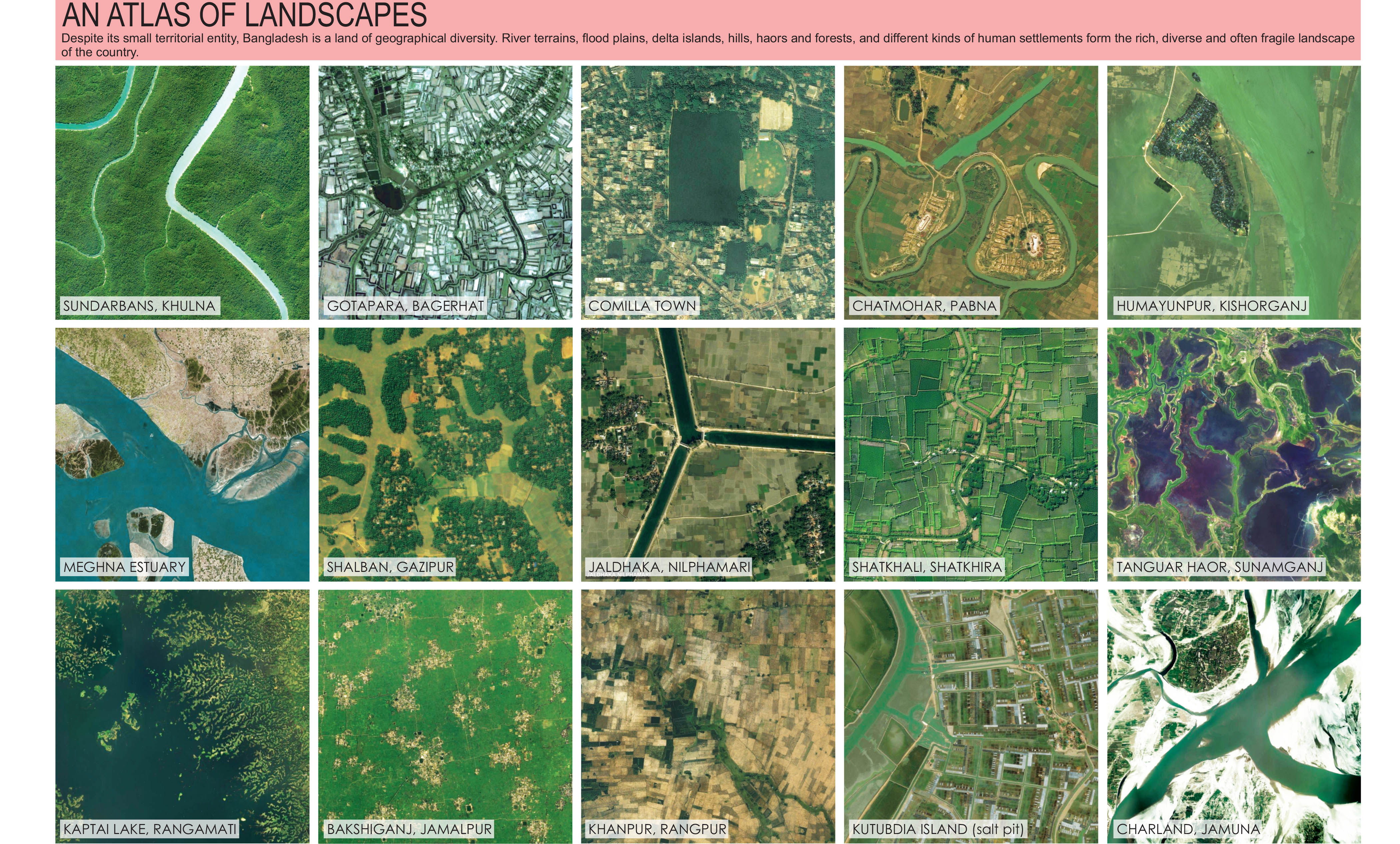
Ecological sustainability can be an ally to economic drivers. Despite its small territorial entity, Bangladesh is a land of geographical diversity. While the predominant narrative is around river kissed flood plains, there are unique hills, haors and forests.
Ecosystems are not abstractions; they provide actual and real values to its human inhabitants. Each ecological zone has both economic and existential values providing a unique and rich source of life-sustaining materials (see An Atlas of Landscapes). Any national development that disregards the complex, multi-dimensional ecosystems will produce a fragile, short-sighted scenario.
Ecological processes can be created or jump-started. An exemplary possibility is char forestation. Char-lands cover approximately 6 percent of the total land area of the country (CEGIS, 2000). On the other hand, Bangladesh has a forest area of about 11.2 percent of the total area of the country (ADB, 2016). Between 1990 and 2010, the country has lost 840,000 hectares of forest cover at a rate of 42,000 hectares per year (FAO). At least 25 percent forest cover is essential for maintaining biodiversity and ensuring ecological goods and services, such as clean air, clean water, carbon sequestration, and flood control in a country. As a result, Bangladesh is in dire need of increase in its greenery in order to achieve environmental sustainability. An increase in forest cover can happen through afforestation, reforestation and natural expansion of forests. Chars that are not eroded in the first four years of their emergence could be used for forestation, cultivation or settlement, and a renewed functioning of the ecosystem.
New Regional Formations Can Trigger Economic Dividends
Redefined regions can be the basis for development strategies for economic investments, urban clustering and landscape management. Bangladesh is already formed by regional varieties defined by geographic and cultural distinctiveness that is often aligned with administrative boundaries. New urban clusters - conurbations - may be planned according to the economic and ecological potentials and conditions of each region.
‘Dhaka Nexus’ is a proposed regionalisation of Dhaka and its surroundings that reorganises the ensemble of towns and settlements in a two-hour or less travel distance around Dhaka, along with a revision of transport network. The goal of Dhaka Nexus is to deflect singular attention on Dhaka city, and decongest it. Other regions may be imagined that also deflect attention away from Dhaka, but more importantly heighten the potentials of those regions. We imagine the following regional formations around towns upgraded as ‘metro-hubs’, each one according to its new regional potential: Chittagong, Rangpur, Khulna, Rajshahi, Sylhet, Mymensingh, Comilla and Barisal.
Digitisation and electronic network is the new reality, the properties of which are going to expand exponentially. Regionalisation and new clustering of towns will become effective with adoption of various digital services (in education, recreation, and employment), and which will not require frequent travel to the metropolitan centres.
Nodes and Roads Form Axes of Development
A transformation of settlement patterns requires an equally robust overhaul of the national transport system. People are now moving more than ever, from one town to another, from one region to another, and even from the nation and beyond. Movement of goods remains the backbone of the economic dynamic. Existing networks of movement - rail, road and river - need to be reorganised, augmented, and transformed. While all these involve long-term engagements, our point is to consider them in the future physical planning of Bangladesh.
We imagine two major north-south transport axes running the full length of the country: the Rangpur-Payra Axis and the Sylhet-Cox's Bazar Axis. An east-west link may be imagined connecting Sylhet and Bogra via Mymensingh, one that is non-existent now. Cross links connect other cities and towns. A river-sea link may connect Dhaka and Chittagong via Barisal. Transnational axes of movement may link different points outside the country. With rivers as a pre-existing infrastructure and after being dredged, they can become major arteries for cargo movement lessening the load on road traffic.
Tourism, a very underperforming sector, can benefit from transport developments. With Bangladesh's rich tapestry of landscapes and warm confluence of traditions, international tourism can be a highly profitable enterprise if organised with national planning of tourist nodes and transport corridors.
Planned Habitats and Food Security Are Related
Bangladesh has made great strides in food production, but at the same time arable land has decreased from 73 percent in 1989 to 59 percent to 2012 (according to FAO). Out of our zeal of developing metropolitan infrastructural spectacles, we should not forget food security for the nation unless we want to fashion ourselves as a service economy like Singapore or Dubai. Additionally, climate-change may affect the complex, diverse and sensitive ecosystems that are foundations of food production.
Planned agglomeration of habitats, settlements and industries with precise footprints need to be determined, with releasing rest of land for agriculture, as well as hydrological flows. Traditional land division and homestead distribution have not helped in consolidating productive land. Consolidation of villages can provide cohesive communities, concentrated services and utilities, efficient roadways, and open up land for large-scale agricultural and fish cultivation.
Consolidation of villages may allow creating new social and cultural hubs.
With Bangladesh's 80,000 villages, Abul Khair imagines such a hub for a cluster of four villages. Each hub on a 15 bigha land may have playfields and clubs to cater to theatre, music and other recreational activities. In the towns, many of the old movie theatres may be mobilised as new cultural hubs.
---
Research and design were directed by Kazi Khaleed Ashraf and Saif Ul Haque with Masudul Islam and Nusrat Sumaiya. Team members include: Tazrin Ahmed, Dhrubo Alam, Muntakim Haque, Maria Kipti, Rifat Ara Mostafa, Rubaiya Nasrin, Mahmudur Rahman Rafat, Arfar Razi, Afreen Ahmed Rochana, Sumaita Tahseen, and Zarin Tasnim.
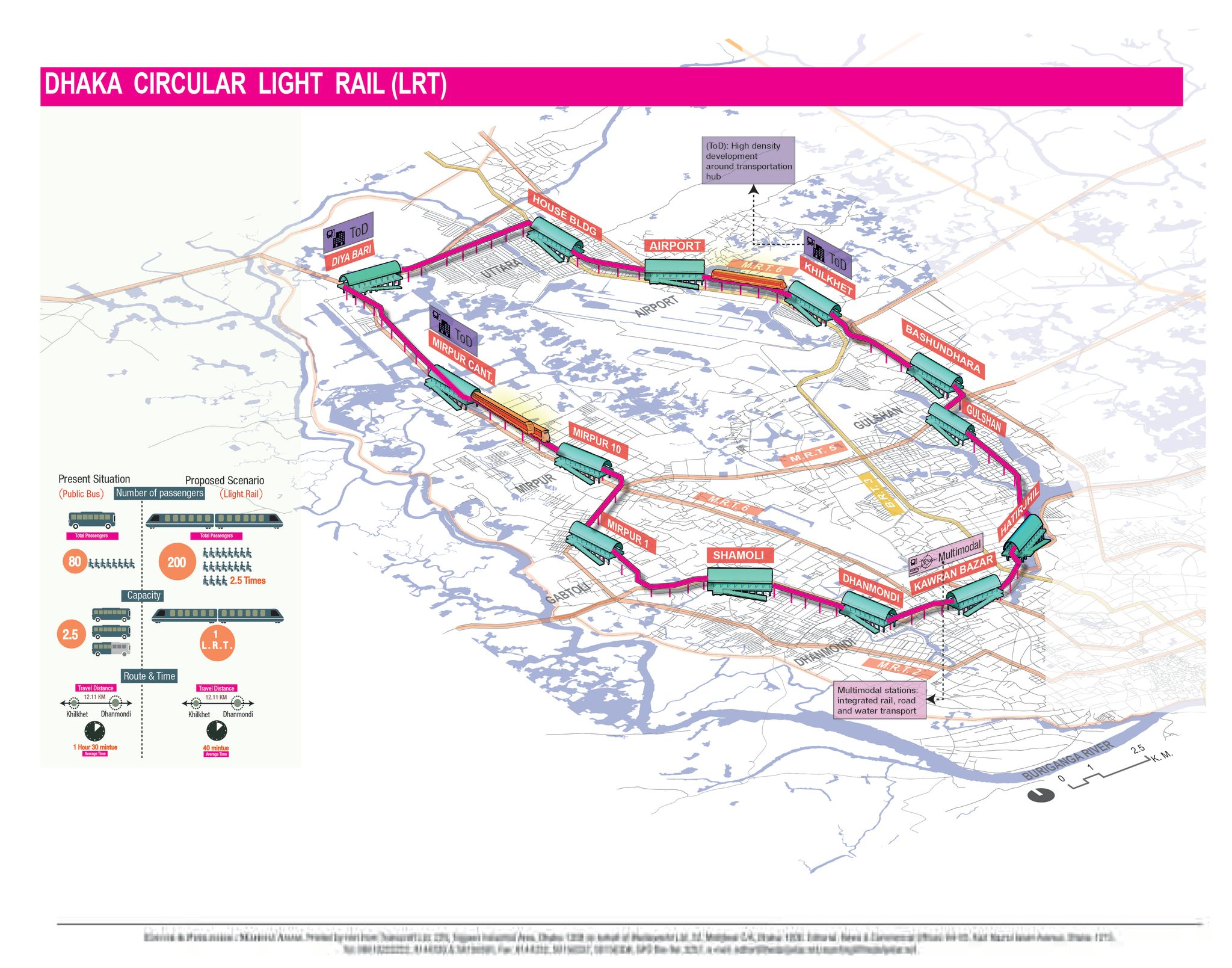
An Idea for a Circular Light Rail (LRT) for Dhaka City
A 40 km LRT connecting major areas of the city
Despite being one of the fastest growing and most densely populated cities in the world, Dhaka has a rudimentary transportation system with some unique characteristics, such as absence of properly planned and organized mass transit system, excessive number of NMTs, dearth of road space which is shared by heterogeneous traffic mix.
With a huge population of over 15 million, concentration of both motorized and non-motorized vehicles, inadequate transportation facilities and policies, varied mixture of traffic, absence of dependable public transport system, inadequate traffic management practices and parking facilities have intensified the traffic congestion and environmental problems in Dhaka.
The only way the traffic and transportation problems in Dhaka can be solved is by upgrading the public transport especially the Mass Rapid Transit system which can serve maximum people with minimum traffic. Public transport system not only circles around the challenges of mobility but it is also an integrated vision comprising urban culture, environment, infrastructure and social practices.
The proposed Light Rail Transit (LRT) imagined by Bengal Institute, will operate as a circular line passing through Uttara, Airport, Khilkhet, Badda, Gulshan, Tejgaon, Kalabagan, Dhanmondi, Sher-e-bangla Nagar, Adabor, Mirpur, Pallabi and Turag. The line can also draw passengers from nearby Dakshinkhan, Rampura, Ramna, Shahbagh, New Market, Mohammadpur and Kafrul area.
The line may serve from about 2 million to more than 3.5 million people depending on various aspects, such as locations of stations, feeder service, other provisions for better accessibility etc. The number of total trips generated by these people ranges from 3.5 million to 6.8 million daily, 30 percent of which have been assumed to be borne by the proposed LRT. For the circular line, an average of 1 kilometre distance is needed between the stations. Locations of important commercial, transport hubs and busy intersections need to be taken into consideration while choosing the location of the stations. The number of total stations is estimated to be 40, for a 42 km line.
Assuming a 16 hour operation everyday, passenger trips per hour can be from 68,750 to 125,000 respectively. Considering all the costs and taking the overhauling and replacement costs into account, the yearly operation and maintenance cost is approximated at ৳350 crore BDT ($44 million USD) per year. The estimated revenue will be between ৳1,700 crore BDT ($215 million USD) and ৳2,400 crore BDT ($305 million USD) per year for different but reasonable fare structures, that is if the fare range is between ৳50 and ৳200 BDT.
Project developed by:
Kazi Khaleed Ashraf; Dhrubo Alam and Masudul Islam
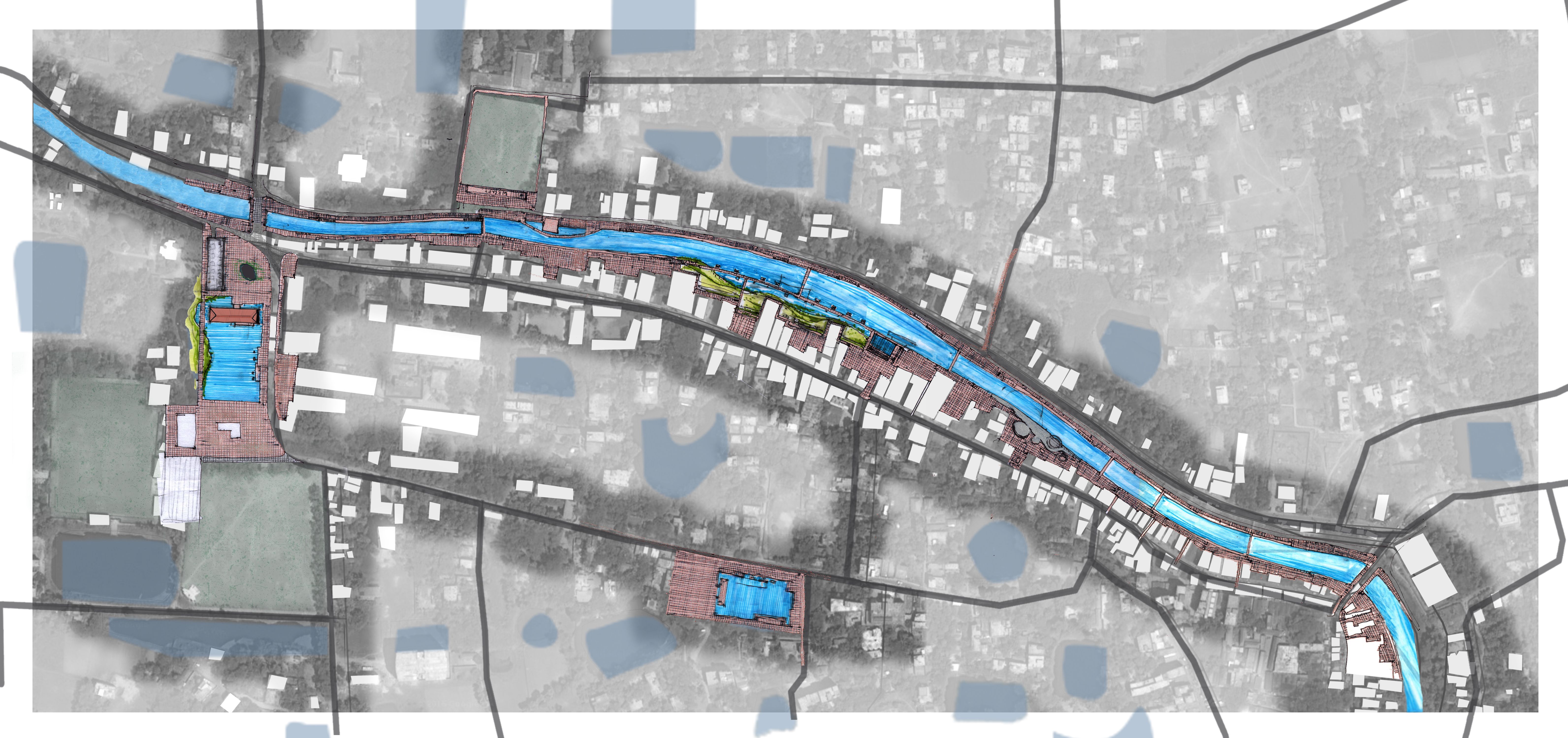
Manikganj Townscape
Developing an Urban Plan for Manikganj
Manikganj is situated 68 km south-west from Dhaka, on the bank of Kaliganga river. The town was probably named after a Muslim preacher, Sufi Manik Shah, who lived on an island by the Ichamati river, presently known as Maniknagar. He would later move near Dhaleswari river, which became the Manikganj town in the early 19th century. Evidences found by the old ghat (jetty), the ancient temple and bazaar shows the settlement flourished as a ganj (a port town) and its main accessibility was provided by the Kaliganga river and a canal named Nodi Balabanta.
Interestingly, the name cannot be found in official records until 1845. In that year, Manikganj Mahakuma (an administrative unit equivalent to a sub-district) was established by the British administrators. It finally became a municipality in 1972. The area of the municipality is 42.38 square kilometre. and population in the year 2011 was 71,698. The population has increased to almost 200,000 at present (the figure includes floating population).
The development proposal for Manikganj also involves restoration of the canal. Rethinking Manikganj is part of a wider scheme by Bengal Institute called ‘Dhaka Nexus’ which seeks to develop the towns around Dhaka in order to reduce the ever increasing pressure on the already overburdened capital. The scheme imagines developing infrastructure to make small towns more livable while maintaining their unique identities. Situated only a few kilometers away from Dhaka, Manikganj is a prime candidate for this process; it has all the possibility of becoming a more livable city with adequate employment, quality educational and healthcare institutions, and functioning transportation system.
Manikganj Town Plan
Manikganj can be an excellent cultural hub by improvising the cultural activities in existing settings. Situated amidst a lush green landscape, the city provides ample open spaces between government institutions and transport corridors, in between buildings and around the neighborhoods. The dispersed open spaces, ponds and canal fronts, river bank, unutilized spaces between buildings, neglected children’s parks and unplanned residential areas can be reorganized by an integrated land-use plan.
Comprehensive Waste Management
Although, Manikganj Municipality was established in 1972, there is no waste-management-system in the town yet. As a result, the leftover spaces beside roads, canals, ponds and backyards of residential areas are often encroached by disposing waste. Scattered garbage pollutes the environment and spreads infectious diseases. A comprehensive waste management system has been designed to ensure a cleaner and healthier environment in Manikganj town.
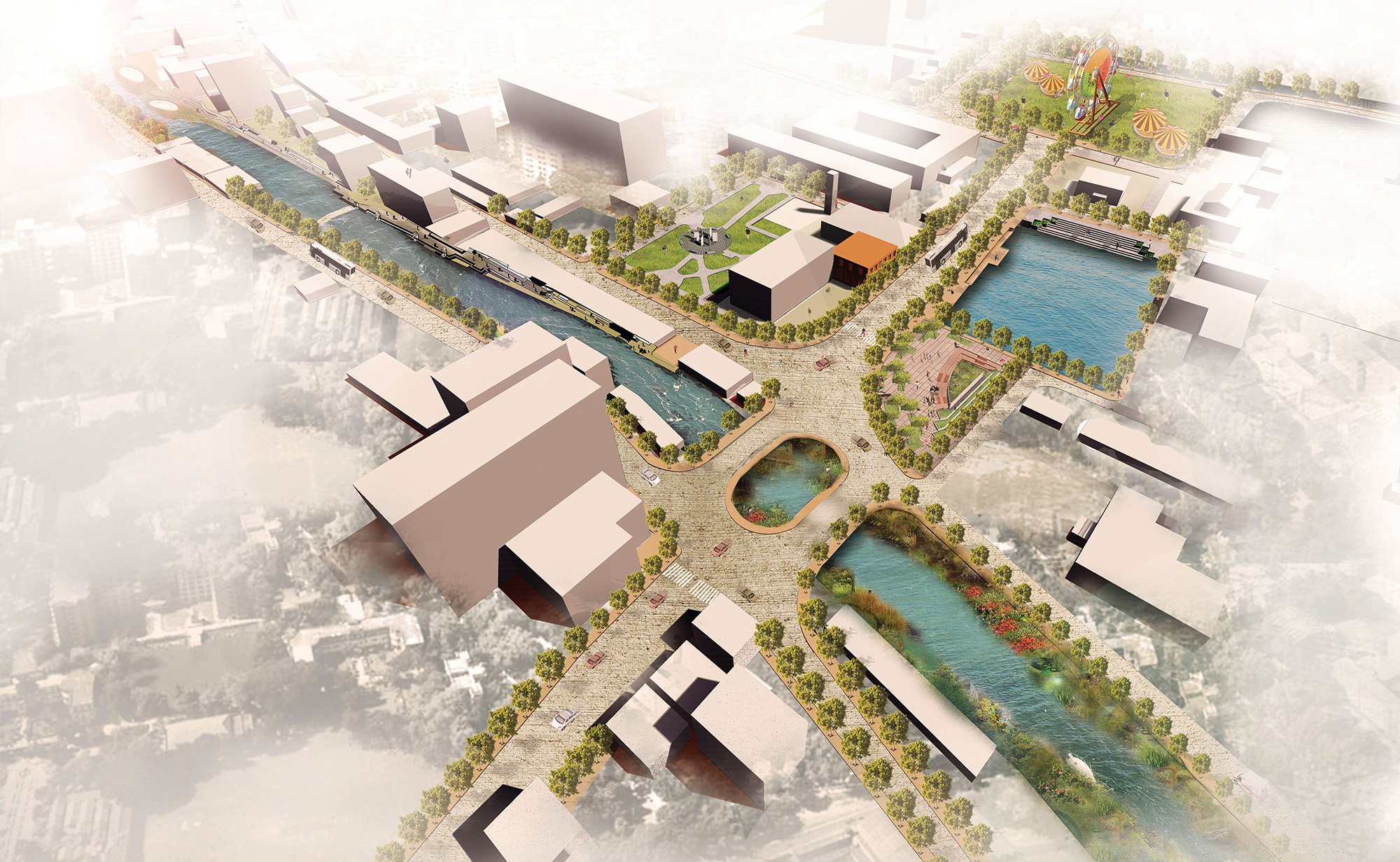
Canal Redevelopment
There are several interconnected canals that connect the river and numerous ponds in Manikganj. Therefore, redesigning a canal-front to reclaim public spaces would be the an ideal solution to reinvigorate the city. One particular canal, Nodi Balabanta, was selected for its location and historical background to set an example for revising water bodies. It flows through the heart of the town beside an old bazaar; and using the waterway, it had a strong connection with other parts of the country. The canal can still provide a circular water transportation network for the city. Both the sides of the canal can be transformed into lively urban spaces for the inhabitants to promote environmental and health benefit.
Creating an Urban Corridor
The main access road to Manikganj Sadar, connecting the National Highway to the regional highway and passing through Rafiq Chattar and Bijoy Mela Math will be converted into an urban promenade incorporating feeder roads, bridges, sidewalks, open spaces, water bodies and built structures.
Project developed by:
Farah Jalil, Hassan Mohammad Rakib and Sumaita Tahseen
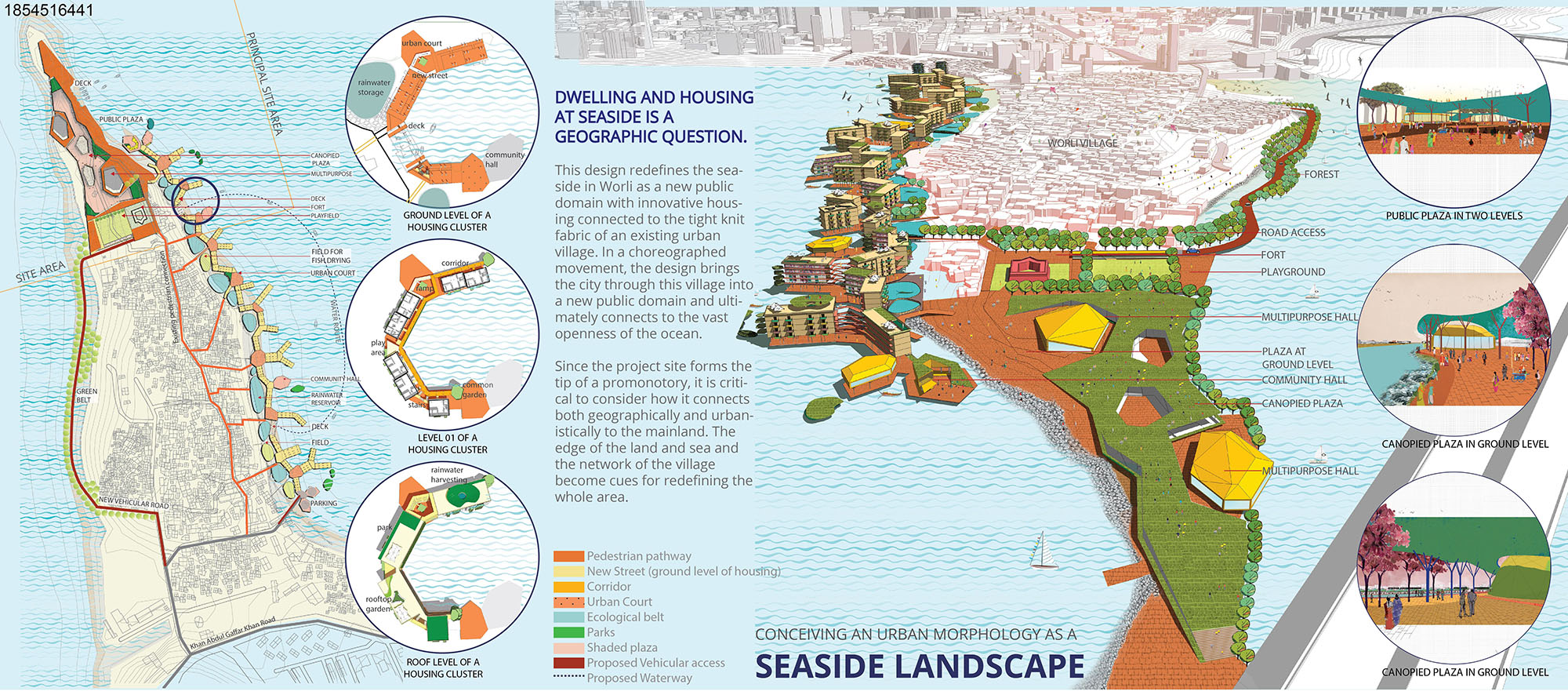
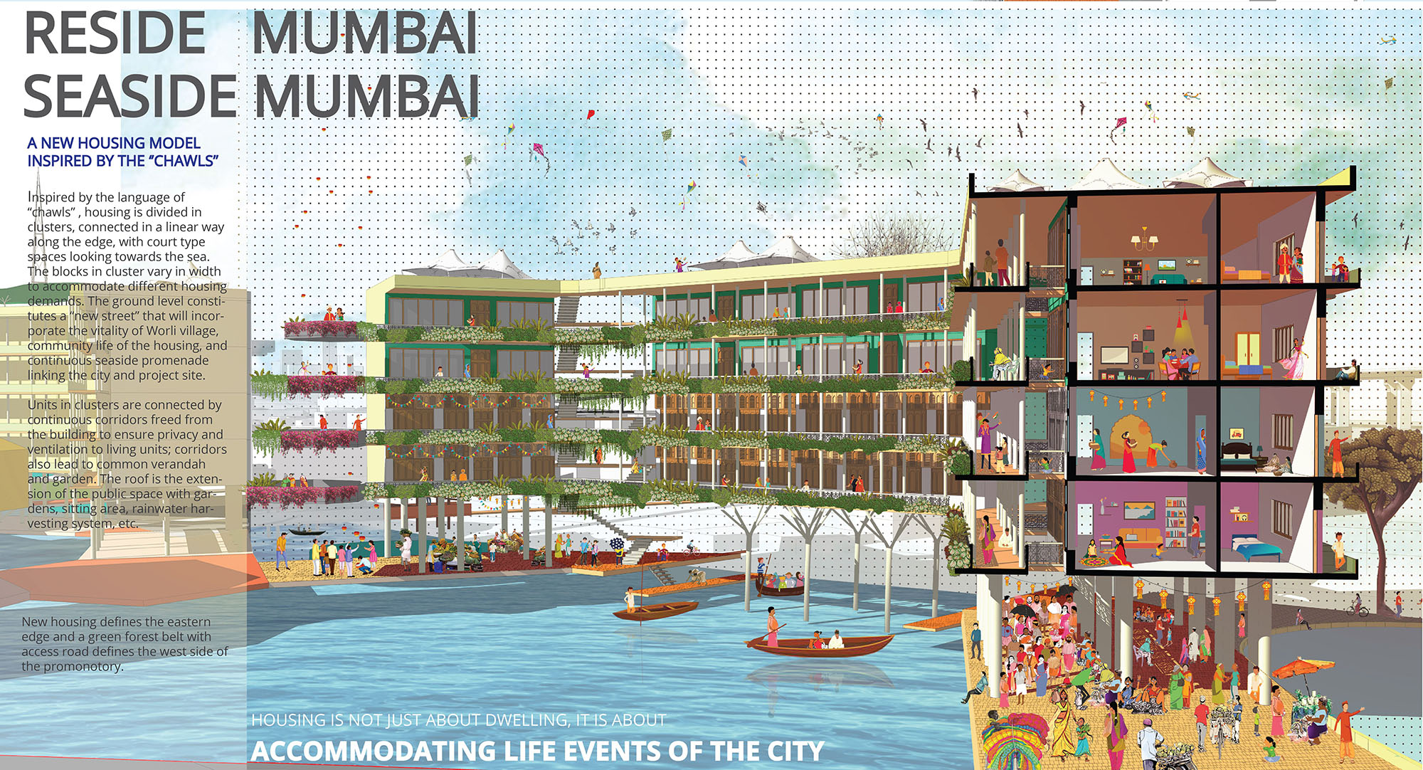
Reside Mumbai, Seaside Mumbai
A Hypothetical Scheme for a Seaside Housing in Mumbai, India
Dwelling and housing at the seaside is a geographic question. The proposed design redefines the seaside of Worli in Mumbai as a new public domain with innovative housing connected to the tight knit fabric of an existing urban village. Inspired by the language of “chawls” in Mumbai, housing is divided in clusters, connected in a linear way along the edge, with court type spaces looking towards the sea. The blocks in cluster vary in width to accommodate different housing demands. The ground level constitutes a “new street” that incorporates the vitality of Worli village, community life of the housing, and continuous seaside promenade linking the city and project site.
Project developed by:
Rubaiya Nasrin and Sumaita Tahseen
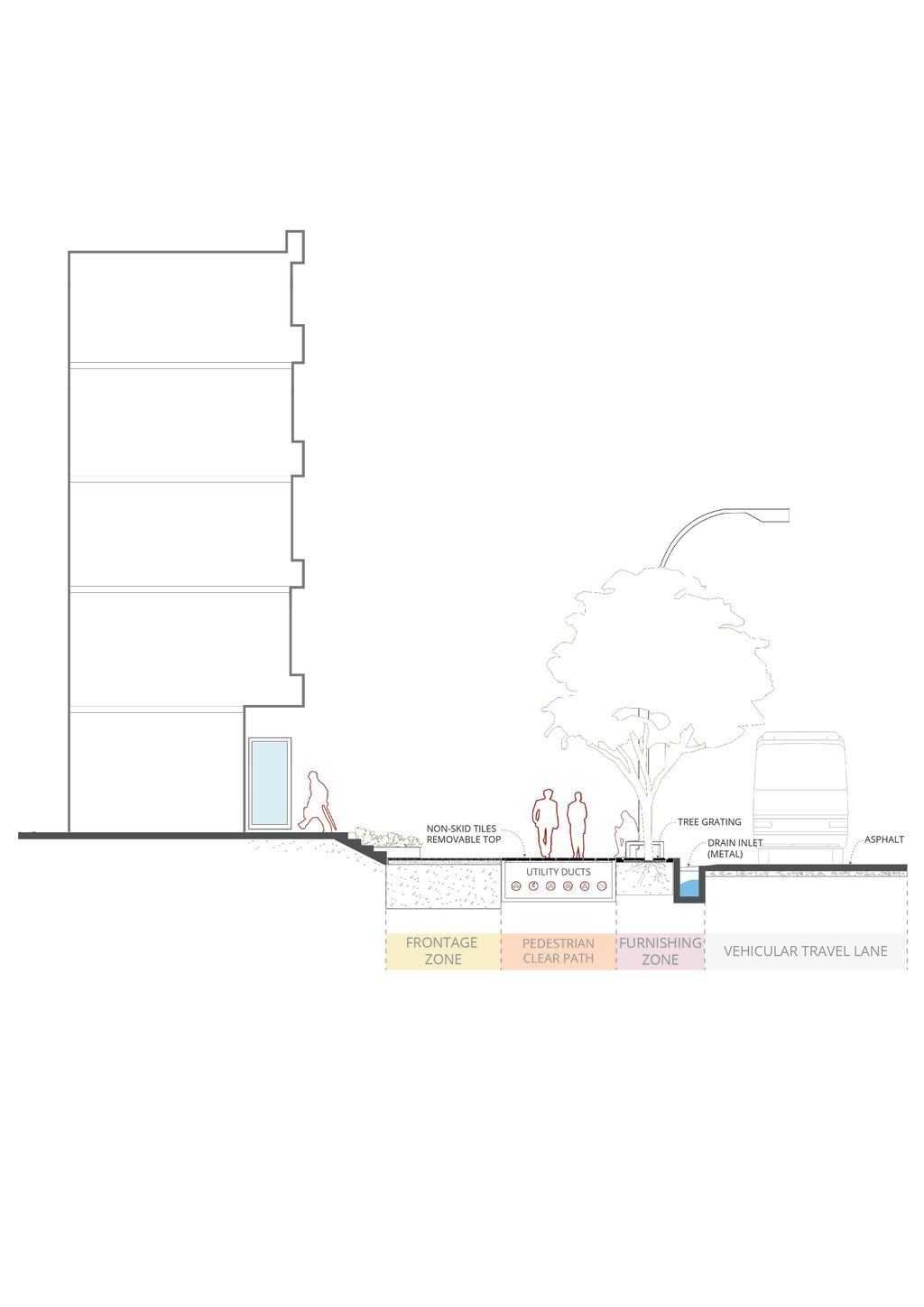
Footpath Design Guideline
An initiative to create better walkable environment for cities in Bangladesh
Bangladesh in its recent past has been experiencing a rapid transformation of the urban environment. The pressures of growth in existing and emerging towns and cities have created an unsatisfactory condition of the urban environment which is visible in almost all of its aspects be it in housing, mobility or public places. While urgent attention is required for all segments, Bengal Institutes’s study deals with walkability and pedestrian movement.
Quality of services associated with mobility is one of the core elements of a healthy city that none of the cities in Bangladesh currently have. The most crucial and important form of mobility - walking - has not been promoted while developing our cities. The movement system in an urban environment comprises of footpaths, streets, roads and rapid transit systems and all their interconnectedness. Footpaths are an essential component of an urban system that works both in conjunction with the road and street network and independently. They are considered to be the vital element of transport infrastructure for providing walkable environment, something that is essential to ensure quality of life in cities.
Walking and walkability enhances social cohesion, increases mobility and access to opportunities connected to individual independence and well-being. A city with an inherent well designed and well-connected network of footpaths, offers walkable environment for its dwellers, and is without a doubt clean, healthy, happy, economic and sustainable. Shifting urban design and planning paradigm towards making better walkable cities can solve major environmental, socio-economic and public health issues that most of the urbanites are suffering from.
Footpaths are not just paths where people walk. They offer space that unite pedestrians, give them opportunity to socialise, a sense of belonging and draws significance to certain locality through activities. In short, footpaths form a linear landscape, a prolonged public space that give urbanites right to walk and be citizens of the city.
Project developed by:
Tazrin Ahmed, directed by Saif Ul Haque